This guide is for the hunter willing to wait on a scarce tag in exchange for a mid-to-late-November mule deer season. The comparison matters because a late date can put a hunter near peak breeding behavior, but it does not solve the harder questions: how the tag is allocated, whether the useful country is legally reachable, and whether a strong harvest percentage came from a stable sample.
Three local Hunt Planner records show three very different versions of that opportunity. Utah DB1020, Dolores Triangle is a nine-day buck hunt with 15 permits in 2026. Idaho 1043, Area 54 is a 16-day antlered-deer hunt with 20 tags and a random draw. Wyoming 110-1, Hunt Area 110 is a 20-day limited-quota hunt in an area Wyoming describes as entirely public, although designated wilderness changes the do-it-yourself equation for nonresidents.
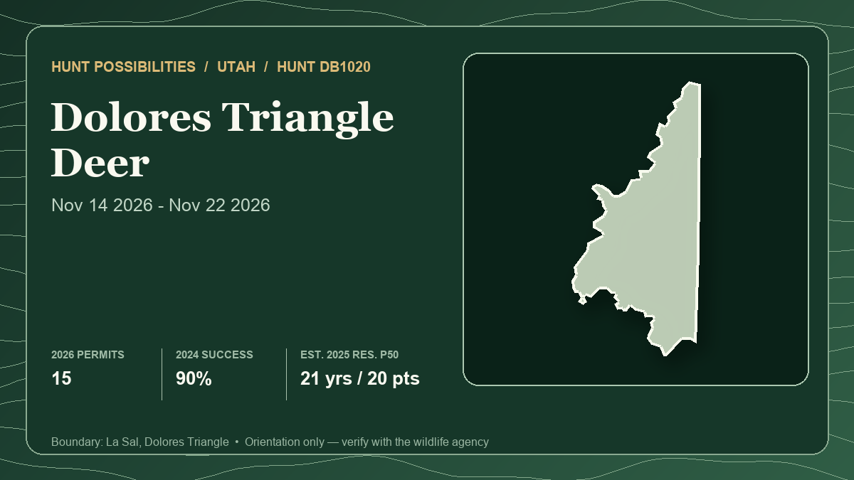
The card above represents lead hunt Utah DB1020 only, not the full comparison. It uses the connected 2026 season and permit count, 2024 harvest report and 2025 draw history for that specific hunt. Those years differ because the newest official record is not the same year for every evidence field.
What a November date changes—and what it does not
Utah's current statewide mule deer plan says the rut peaks in mid-November. That makes all three seasons relevant to the same planning question: can a hunter use doe-group activity and seasonal movement to find bucks that were harder to observe earlier?
The practical answer is conditional. Breeding behavior can increase daylight activity, but weather, elevation, local deer density and hunting pressure still decide what is visible. A season printed over peak rut is not a guarantee that a particular buck will occupy open ground. Nor does snow automatically produce an easy migration hunt. A warm, dry November can leave deer distributed across broad transition habitat; a strong storm can move deer while also closing or degrading the roads a hunter expected to use.
Start with habitat patterns instead of a pin. Map connected blocks of seasonal range, broken cover beside feed, lower-elevation transition bands and doe-group observation country. Then test whether each block has a legal arrival, a realistic retrieval and an alternate plan if weather removes the first access route.
At first and last light, watch broad habitat edges and openings without crowding them. During the middle of the day, narrow the search to cover near recent doe activity rather than walking every drainage. Fresh sign and current observation should outrank a preseason assumption. If a buck moves with does into thick or broken terrain, waiting for a safe reappearance is usually better than forcing a rushed angle.
The comparison below uses the same fields for each hunt. Draw results describe historical applicant pools, not future probabilities. Harvest percentages describe past hunters, not deer abundance or trophy quality. A 20-tag result also carries much more year-to-year noise than a large general-season sample.
Hunt 1: Utah DB1020 — short season, tiny quota, desert-canyon logistics
- Current season and weapon: Buck deer, any legal weapon, November 14–22, 2026. Utah lists 15 permits: 13 resident and two nonresident.
- Tag path or draw system: Utah limited-entry bonus-point draw. The official 2025 report separates bonus permits from regular permits, so low-point random opportunity can exist even when the highest-point applicants take the bonus allocation.
- Latest draw demand: In 2025, 507 eligible resident applicants competed for 11 permits, an aggregate historical ratio of one permit per 46.1 applicants. The report lists 444 eligible nonresident applicants and one permit, or one per 444. A permit appeared as low as three resident points and five nonresident points, but those isolated random results are not a forecast.
- Latest harvest result: Utah's final 2024 report lists 11 hunters afield, 10 bucks harvested, 90% success and 3.7 average days afield. Eleven hunters are too few to treat 90% as a stable expectation.
- Public-land and access pattern: The official boundary must be paired with current ownership and travel layers. A BLM planning appendix says the Dolores Triangle Habitat Management Plan covers 100,686 acres of BLM-administered public land and identifies mule deer winter habitat from November 1 through May 1. That planning-unit figure is useful context, not a current public-land percentage for DB1020 or proof that every public parcel has a public route.
- Terrain character: A high-desert canyon-and-bench problem. Broken rims, shrub openings and pinyon-juniper cover create strong observation opportunities, but deep relief can turn a short map distance into a slow pack-out.
- Principal tradeoff: The dates align tightly with Utah's stated mid-November rut peak and the 2024 success was high, but the season is only nine days and both applicant pools were exceptionally restrictive.
- Best for: A hunter who already values Utah bonus points, can dedicate scouting to a small-window hunt and is comfortable building redundant road and retrieval plans.
Open DB1020 in the Hunt Planner 3D map.
Hunt 2: Idaho 1043 — random draw, longer window, mixed ownership
- Current season and weapon: Antlered mule deer or white-tailed deer, any weapon, November 15–30, 2026, with 20 tags. IDFG defines the hunt as antlered only and requires at least one antler longer than three inches.
- Tag path or draw system: Idaho controlled hunts use a random drawing rather than a preference-point ladder. A valid Idaho hunting license is required to apply, and the current hunt number—not merely the unit number—belongs on the application.
- Latest draw demand: IDFG's live 2026 table lists 1,000 resident first-choice applicants for 18 awards, displayed as 2%, and 243 nonresident first-choice applicants for two awards, displayed as 1%. Across both residencies, 1,243 first-choice applicants sought 20 tags. The local static profile still preserves the 2025 row, so the article uses the live 2026 table for the newest demand and labels the difference.
- Latest harvest result: In 2025, 20 hunters reported 19 deer for 95% success over 82 hunter-days, or 4.1 days per hunter. IDFG reports that 88% of harvested bucks had at least four points and 6% were white-tailed deer. Those fields help identify the result as predominantly mule deer, but they do not establish antler size or future quality.
- Public-land and access pattern: IDFG summarizes the 873,344-acre hunt area as 40.7% private, 34.6% U.S. Forest Service, 22.8% BLM and 1.9% State of Idaho management. It lists no current Access Yes! property and no federally designated wilderness inside the hunt. Surface management is not the same as ownership or legal access, so parcel continuity and current travel plans still control the route.
- Terrain character: A large mountain-rangeland mosaic with forested public ground, open country and private agricultural interfaces. The size favors several independent observation zones rather than one all-or-nothing basin.
- Principal tradeoff: Idaho offers the longest end date and no point debt, but the 2026 odds were about 2% resident and 1% nonresident, while private land accounts for more than two-fifths of the surface summary.
- Best for: A hunter who prefers a fresh random chance each year, wants 16 season days and can do careful ownership work in a mixed public-private unit.
Open Idaho 1043 in the Hunt Planner 3D map.
Hunt 3: Wyoming 110-1 — all-public on paper, wilderness reality in practice
- Current season and weapon: Antlered mule deer or any white-tailed deer, November 1–20, 2026, with any legal weapon. The limited-quota Type 1 season overlaps the area's October 15–November 10 general season rather than starting after all general pressure ends.
- Tag path or draw system: Wyoming residents enter the limited-quota resident draw. Nonresidents navigate regular and special pools with preference and random components. Pool and point tier matter; one blended percentage would misstate the system.
- Latest draw demand: The official Hunt Planner shows a 2025 Type 1 quota of 20 against 319 resident first-choice applicants, or 6.27%. The connected 2025 nonresident tables show no Type 1 licenses in either random pool. One regular preference license issued at 18 points, while the small special preference allocation reached different tiers. With only a handful of nonresident licenses, a single application can materially change a reported tier.
- Latest harvest result: Wyoming's 2025 mule deer report lists 138 hunter-days, 15 mule deer harvested and 68.2% success for Area 110 Type 1. The connected record equates that to 22 hunters and 9.2 days per hunter. The same official page separates white-tailed-deer harvest and shows no Type 1 whitetail harvest for the row.
- Public-land and access pattern: WGFD describes Area 110 as 100% public with good access and says the entire area is public. It also lists the Washakie and North Absaroka wilderness areas. Wyoming requires a nonresident hunting big game inside federally designated wilderness to have a licensed outfitter or a properly licensed resident guide. Therefore, “100% public” does not mean “100% nonresident DIY.”
- Terrain character: Mountain and wilderness country where elevation, snow, stock or foot travel and retrieval capacity can matter more than road density. A late hunt here should be planned around conservative travel time and a weather-safe exit.
- Principal tradeoff: This has the strongest public-land headline and the best 2025 resident first-choice percentage of the three, but the resident draw was still only 6.27%, nonresident allocation was minute and wilderness rules can reshape the usable map.
- Best for: A Wyoming resident prepared for mountain logistics, or a nonresident who already has a lawful wilderness strategy and understands the separate draw pools.
Open Wyoming deer 110-1 in the Hunt Planner 3D map.
A late-season plan that survives changing conditions
Build the plan backward from retrieval. For each observation zone, estimate the time from a legal vehicle location to the farthest ethical shot opportunity, then add the time required to reach, field dress and pack an animal in darkness or snow. If that total does not leave margin, reduce the zone before the hunt.
Next, separate deer-finding from buck-finding. First locate current doe use across feed-cover edges and seasonal transition habitat. Then watch how bucks enter, leave and circle that activity. During the rut, a buck may travel more, but the hunter still needs a clean identification, a safe background and enough time for recovery.
Weather needs two plans. A dry plan can use higher observation and a broader elevation range. A snow plan should assume slower roads, shorter glassing sessions, colder batteries and a more demanding pack. Neither plan should depend on a single unverified gate, a private shortcut or a precise location borrowed from someone else's report.
Finally, manage pressure. Opening-day visibility can draw several parties to the same accessible public edge. Keep alternatives in different parts of the unit, avoid pushing deer toward roads or private land and do not crowd another hunter's active setup. The scarcity of the tag does not justify a risky shot or an access shortcut.
Best fit by hunter priority
- For a resident choosing the least restrictive recent draw: Wyoming 110-1 showed 6.27% resident first-choice odds in 2025, versus Idaho's 2% in 2026 and Utah's aggregate one-in-46.1 resident ratio in 2025. Different years and systems prevent treating those as a permanent ranking.
- For a hunter who refuses to build point debt: Idaho 1043 is the cleanest fit because its controlled hunt is random. The price of that simplicity was a 1–2% first-choice result in 2026.
- For the hunter prioritizing a tightly timed rut window: Utah DB1020 sits directly over Utah's stated mid-November peak, but it also has the shortest season and the most restrictive aggregate nonresident result.
- For public-land scale: Wyoming 110-1 has the strongest official summary. For a nonresident, the wilderness guide requirement must be solved before that headline has practical meaning.
- For maximum calendar flexibility: Idaho runs through November 30. That extra time is only useful if ownership, snow and road status preserve access.
There is no universal winner. Utah provides a bonus-point path with a random component, Idaho resets the contest through a random draw, and Wyoming divides residency and nonresident pools differently. Their harvest samples are also tiny: 11 Utah hunters in 2024, 20 Idaho hunters in 2025 and 22 Wyoming hunters in 2025. Read those results as evidence that successful hunts occurred—not as promises.
Verification checklist before applying or hunting
- Reopen the official 2026 listing and confirm season, weapon, sex limitation, quota and boundary for the exact hunt number or license type.
- Verify the draw pool, residency rules and application deadline; never carry a point threshold or odds percentage forward without its year.
- Recheck parcel ownership, public ingress, gates, road and trail status, fire restrictions and land-manager travel rules immediately before the trip.
- For Wyoming, identify every designated-wilderness boundary and solve the nonresident guide requirement before treating that country as huntable.
- Confirm hunter-orange, tagging, evidence-of-sex, chronic-wasting-disease and carcass-transport rules for the state and unit.
- Build dry-road and snow-road plans with conservative retrieval times; late-season access can change faster than the hunt boundary.
- Use Hunt Planner for orientation, then carry the current agency boundary and a field-ready ownership source.
The Hunt Planner methodology explains how state-specific draw and harvest fields are preserved without forcing unlike systems into one score. Report a mismatch through the corrections page. Regulations, quotas, draw data, road conditions, wilderness access and private-land permission can change; verify the official sources again before applying and before entering the field.
Sources and verification
- Utah DWR Hunt Planner: DB1020 boundary and connected current hunt record
- Utah DWR 2026 Big Game Field Regulations page and current guidebook
- Utah DWR 2025 limited-entry drawing odds
- Utah DWR final 2024 limited-entry deer harvest report
- Utah statewide mule deer management plan: rut timing, habitat and population context
- BLM planning appendix: Dolores Triangle public-land and mule deer habitat context
- IDFG Hunt Planner: Hunt 1043 season, 2026 draw, 2025 harvest and surface management
- IDFG 2026 Big Game Seasons and Rules
- IDFG controlled-hunt information: limited tags and random drawing
- Wyoming Game and Fish 2026 deer seasons
- Wyoming Game and Fish Hunt Planner: Area 110 season, access, 2025 draw and harvest
- Wyoming Game and Fish draw results and odds
- Wyoming Game and Fish wilderness guide requirement for nonresident big-game hunters
Official regulations and hunt-planner pages control. Utah's latest connected draw and harvest fields are from 2025 and 2024, Idaho's are from 2026 and 2025, and Wyoming's are from 2025. Those data-year differences, small sample sizes and distinct draw systems are explicit because combining them into a single rank would create false precision.